
Port Severn Fish Spawning Habitat Enhancement Project
Port Severn, Ontario Canada
The Severn River, in central Ontario, flows generally northwest from Lake Couchiching and Lake Simcoe into Georgian Bay at Port Severn. Where the Severn River outlets into Georgian Bay, just below the Lock 45 and Bayview dams, is an important spawning and harvest area for walleye, lake sturgeon, and other Great Lakes species. This area has supported an important traditional harvesting fishery for Indigenous communities since time immemorial and is one of only two known spawning sites for the Severn Sound walleye population, which experiences some of the highest recreational fish harvest in Georgian Bay. Fish habitat in this area has been subject to human alteration over time, impacting fish production potential. Along with restricting access to upstream spawning areas, the construction of the Bayview and Lock 45 dams in the early 1900s also reduced substrate suitability in downstream reaches of the Severn River (Figure 1). Variable water flows through the Bayview and Lock 45 dams combined with a loss of spawning habitat have reduced fish production, leading to declining fisheries in the Severn Sound area and more broadly in Georgian Bay.
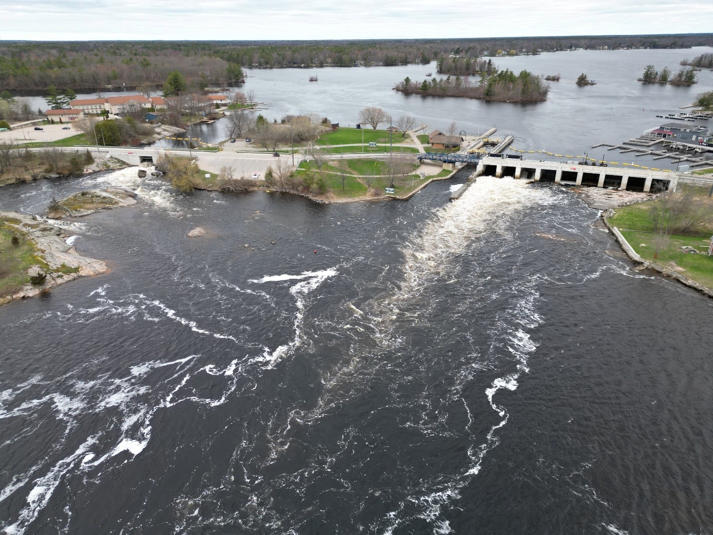
Figure 1. Lock 45 and Bayview Dam, Port Severn. Photo Credit: Parks Canada - Trent Severn Waterway.
Parks Canada currently owns and operates both the Bayview Dam and the Lock 45 Dam. Parks Canada, along with other project partners including the Severn Sound Environmental Association (SSEA), Georgian Bay Mnidoo Gamii Biosphere (GBB), and the Ontario Ministry of Natural Resources (OMNR) , the Department of Fisheries and Oceans Canada (DFO) and others, are interested in improving the quality of spawning habitat in this area through substrate augmentation, as well as developing guidance on a flow regime during the spring spawning season that will promote conditions suitable for walleye and lake sturgeon reproduction and egg/larval survival.
The Area of Interest for this habitat restoration project is a 9.3-hectare study area that extends downstream of the Bayview and Lock 45 dams to where the Severn River outlets into Severn Sound (Figure 2). The objective of this project will be to enhance reproductive habitat for lake sturgeon, walleye, and other elements of the fish community through flow modification and substrate addition, primarily focused on species reproductive habitat (substrate and flow) during spring/early summer (March-June). An earlier restoration project (1979) did enhance the spawning shoal downstream of the Bayview Dam, however, other locations in the Area of Interest show promise for restoration. Additionally, an extensive survey of the walleye spawning shoal below Bayview Dam was completed in 2018 by SSEA staff which will provide additional background information.
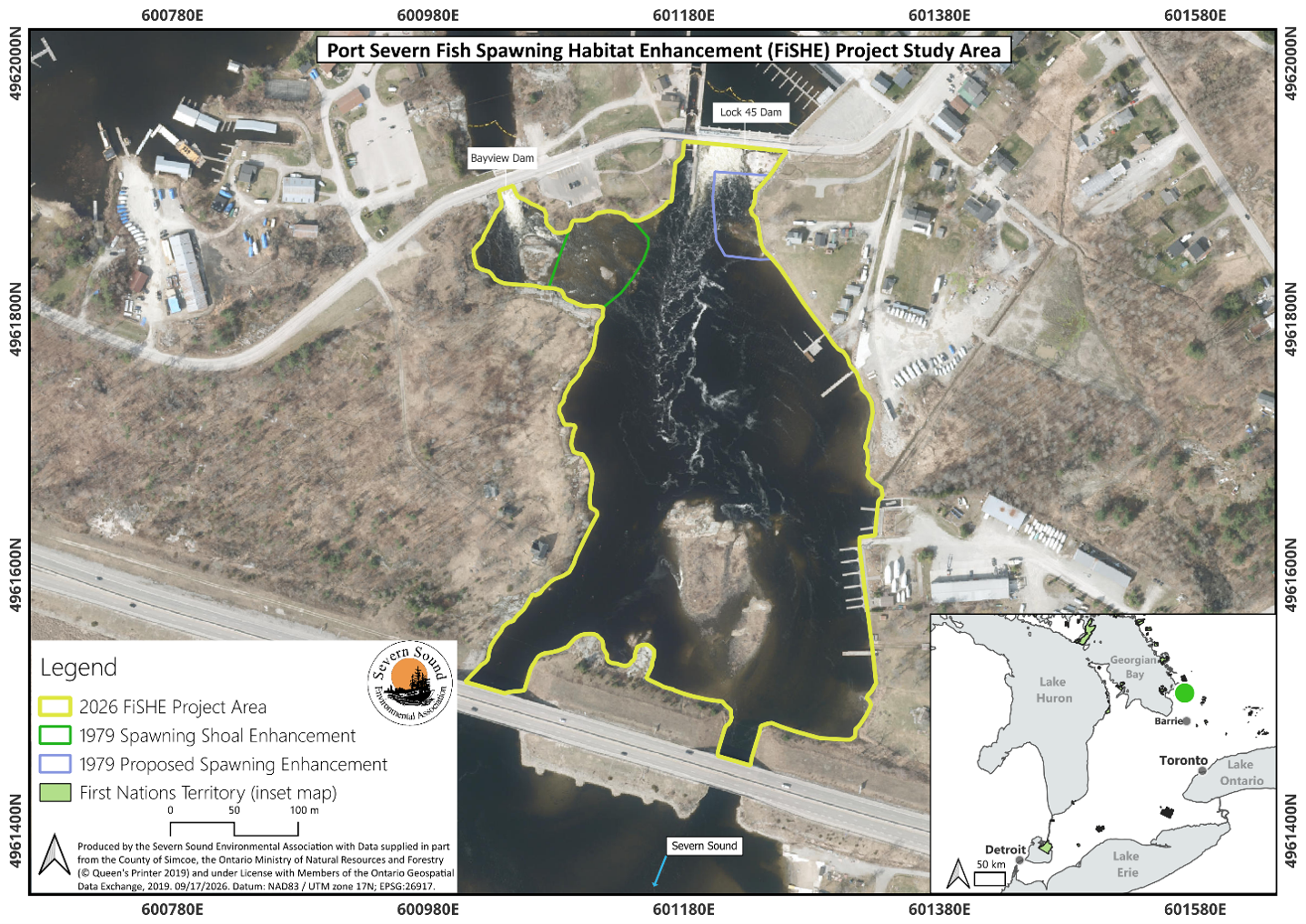
Figure 2. Port Severn Fish Spawning Habitat Enhancement Project Study Area and Notable Features
A feasibility level study will be completed in the Area of Interest by the project partners, as a part of this project’s Phase I which aims to understand feasible options and develop 30% design plans for the project. These will be used to seek additional funding for final design, permitting, implementation, and assessment. Key components of this feasibility study include: substrate/bathymetric assessment, flow velocity assessment, topographic assessment, pre-implementation biological assessment, thermal assessment, and hydrodynamic model development to explore optimal substrate placement and flow velocity modifications to enhance walleye and lake sturgeon spawning habitat. The GLFC has awarded funding to SSEA and GBB for Phase 1 of the project to complete the feasibility study. SSEA staff will serve as the primary project manager while GBB will coordinate local community and First Nations outreach and engagement.
Any physical data collected as a part of this feasibility study (pre-construction) will be stored internally by SSEA as well as on this website. Hydrodynamic model results will be summarized and provided to SSEA and the GLFC, once complete, and will be available on this website. The data will be available to the public on this website or upon request within 60 days of data validation and entry. All products and data will be available upon request within 2 years of project completion. Biological data will be stored internally by OMNR and available upon request to OMNR.
Contact Jeff Tyson for more information or to make a data request. All future sub-awardees not identified in this plan will have acceptance as a condition of their contract of this data sharing plan. Any additional data sharing stipulations for future sub-awardees may be outlined at that time and described in their contract.