To assess the status of the coastal wetland complex located within Long Point. Analysis parameters will include: water and sediment quality, vegetation
diversity and richness, aquatic invertebrate diversity and IBI scores, fish , marsh bird and amphibian diversity, tributary water quality and landuse impacts.
The results of this study will be used to guide stewardship within the immediate area.
Lead Agency:
LEMU- OMNR
Contact:
J. Gilbert or K. Oldenburg; OMNR Lake Erie Management Unit, P.O. Box 429 Port Dover, ON, N0A 1N0
Partners:
Links:
Documents
Big Creek, Lower Grand
Project Title
Project Type
Basin
Waterbody(ies)
Status
East Basin Rehabilitation Plan:
Habitat monitoring and
East basin
n/a
April 2000 - Dec 2004.
Habitat component
evaluation
Reporting completed in 2005
Location:
North Shore of Eastern Basin
Description:
A component of a 5-yr fisheries management plan that involves fisheries and habitat surveys in the nearshore waters and lower section of tributaries in the
Ontario waters of the eastern basin from Long Point to the Niagara River. The intent of this component is to link key species (yellow perch and walleye) and
the fish community with habitat types in order to identify sites with potential for habitat rehabilitation.
Lead Agency:
OMNR (LEMU)
Contact:
K. Oldenburg, OMNR Lake Erie Management Unit, P.O. Box 429 Port Dover, ON, N0A 1N0
Partners:
EC, OCFA, OFAH
Links:
Documents
Reference #1
Buffalo-Eighteenmile
Project Title
Project Type
Basin
Waterbody(ies)
Status
Buffalo River Walleye introductions
Rehabilitation Projects
East basin
n/a
Project on hold due to disease
(Implementation)
issues with rearing walleye eggs.
Location:
Buffalo R., NY
Description:
Stocking of walleye fingerlings in the Buffalo River in an attempt to establish a breeding walleye population . Project will also monitor water quality and
thermal profiles, and evaluate the overall habitat for possible future improvements.
Lead Agency:
NYSDEC
Contact:
J. Markham, Lake Erie Fisheries Unit – NYSDEC, Dunkirk, NY 14048-1031
Partners:
Southtowns Walleye Association, Erie County Fish Advisory Board
Links:
Documents
Cattaraugus
Project Title
Project Type
Basin
Waterbody(ies)
Status
Cattaraugus Creek Migratory Access
Rehabilitation Projects
East basin
n/a
2005 to completion
Improvement
(Implementation)
Location:
Springville, NY
Description:
This is the initial phase of an investigations into feasibility, costs, and benefits associated with fish passage and sea lamprey attraction /traps at a dam in
Springville, NY on Cattaraugus Ck. Results of this initial study will determine future direction of this project.
Lead Agency:
US Army Corp of Engineers, Erie County
Contact:
J. Markham, Lake Erie Fisheries Unit – NYSDEC, Dunkirk, NY 14048-1031
Partners:
NYSDEC
Links:
Documents
Spooner Ck. Rehabilitation Project
Rehabilitation Projects
East basin
Spooner Creek
Completed
(Implementation)
Location:
Springville, NY
Description:
Bank stabilization project to minimize erosion, stabilize the creek bed, and improve instream habitat and cover. The project mainly involves tree plantings,
but may also include the construction of cribs on high erosion areas.
Lead Agency:
NYSDEC
Contact:
J. Markham, Lake Erie Fisheries Unit – NYSDEC, Dunkirk, NY 14048-1031
Partners:
Western NY Chapter of TU
Links:
Documents
Chautauqua
Project Title
Project Type
Basin
Waterbody(ies)
Status
Chautauqua Creek Migratory Access
Rehabilitation Projects
East basin
n/a
Completed in July 2012
Improvement
(Implementation)
Location:
Westfield, NY
Description:
The is a GLFER project and will provide passage at two fish passage barriers, opening up an additional 10 miles of high quality spawning habitat for steelhead
and other resident stream fishes.
Lead Agency:
US Army Corp of Engineers, Erie County
Contact:
J. Markham, Lake Erie Fisheries Unit – NYSDEC, Dunkirk, NY 14048-1031
Partners:
NYSDEC
Links:
Documents
Chautauqua-Conneaut
Project Title
Project Type
Basin
Waterbody(ies)
Status
Chautauqua Creek Fish Passage
Rehabilitation Projects
Central basin
n/a
2006 to completion
Project
(Implementation)
Location:
Chautauqua Creek, NY
Description:
This is the initial phase of an investigations into feasibility, costs, and benefits associated with fish passage at a pair of dams near Westfield, NY on
Chautauqua Ck. Results of this initial study will determine future direction of this project.
Lead Agency:
US Army Corp of Engineers, Erie County, Village of Westfield, USFWS, and NY Rivers United
Contact:
J. Markham, Lake Erie Fisheries Unit – NYSDEC, Dunkirk, NY 14048-1031
Partners:
NYSDEC, Red House Chapter of Trout Unlimited
Links:
Documents
Crooked Creek Holliday Site Stream
Rehabilitation Projects:
East-Central
Crooked Creek
2011
Enhancement
Implementing strategies,
Location:
Holliday Farms
Description:
This project is a habitat improvement effort.
Lead Agency:
PA Fish and Boat Commission
Contact:
K. Anderson, Division of Habitat Management, Tionesta Pa 16356
Partners:
NRCS Property Owner
Links:
Documents
Design
East Branch of Conneaut Creek
Rehabilitation Projects:
East-Central
East Branch of Conneaut Creek, PA
Completed 2010
Albion Park Stream Enhancement
Implementing strategies,
Location:
Albion Park
Description:
This project is a habitat improvement effort.
Lead Agency:
PA Fish and Boat Commission
Contact:
K. Anderson, Division of Habitat Management, Tionesta Pa 16354
Partners:
Albion Sportsmans Club
Links:
Documents
Design and Permits
East Branch of Conneaut Creek
Rehabilitation Projects:
East-Central
East Branch of Conneaut Creek, PA
2009 Ongoing
Impoundments Preliminary
Implementing strategies,
Restoration Plan
Location:
Erie County
Description:
The PRP has been completed for this project and the project has advanced to the feasibility, design phase. The project involves improving fish passage to a
reach of East Branch of Conneaut Creek by the removal of two dams near Albion PA, restoration of the stream reach impacted by the dam, and the
construction of a sea lamprey control barrier. Results of this feasibility and design phase will determine future direction of this project
Lead Agency:
PA Fish and Boat Commission
Contact:
K. Anderson, Division of Habitat Management, Tionesta Pa 16353
Partners:
US Army Crop of Engineers, Albion Sportsmen's Club
Links:
Documents
Final PRP, Feasibility Study
Elk Creek, Folleys End Stream
Rehabilitation Projects:
East-Central
Elk Creek
2011
Enhancement
Implementing strategies,
Location:
Folleys End
Description:
This project is a habitat improvement effort.
Lead Agency:
PA Fish and Boat Commission
Contact:
K. Anderson, Division of Habitat Management, Tionesta Pa 16356
Partners:
NRCS Property Owner
Links:
Documents
Design
Elk Creek, McKean Reach Stream
Rehabilitation Projects:
East-Central
Elk Creek
2011 ongoing
Enhancement
Implementing strategies,
Location:
Huya Site
Description:
The PRP is under development for this project with anticipation to advance to the feasibility / design phase in 2011.
Lead Agency:
PA Fish and Boat Commission
Contact:
K. Anderson, Division of Habitat Management, Tionesta Pa 16356
Partners:
US Army Crop of Engineers,
Links:
Documents
PRP
Formile Creek Fish Passage
Rehabilitation Projects:
East-Central
Four Mile Creek, PA
2010 Ongoing
Implementing strategies,
Location:
Cassidy Park Millcreek Township
Description:
The project will provide passage at two fish passage barriers.
Lead Agency:
PA Fish and Boat Commission
Contact:
K. Anderson, Division of Habitat Management, Tionesta Pa 16356
Partners:
Lawrence Park Township, DCNR, CZM, Lawrence Park Golfcourse, USF&WS
Links:
Documents
Lower Grand
Project Title
Project Type
Basin
Waterbody(ies)
Status
Evaluation of Southern Grand River
Habitat monitoring and
East basin
n/a
2004. Final Reporting Complete
wetlands between Cayuga and
evaluation
2005
Dunnville
Location:
Bottom 42km of Grand River, Ontario
Description:
Ten wetlands were evaluated in the summer of 2004 for water and sediment quality along with vegetation and aquatic invertebrate and fish diversity and
richness. Surveys were also conducted to determine wetland and river basin bathymetry elevations tied to geodetic benchmarks to assess potential impacts
due to a Dunnville Dam removal scenario.
Lead Agency:
LEMU- OMNR
Contact:
J. Gilbert or K. Oldenburg; OMNR Lake Erie Management Unit, P.O. Box 429 Port Dover, ON, N0A 1N0
Partners:
EC
Links:
Documents
Reference #4
Grand River (Fairchilds Creek)
Rehabilitation Projects
East basin
n/a
Ongoing
Stewardship Initiative
(Implementation)
Location:
Grand River, Ontario (eastern basin)
Description:
Stewardship initiatives in Brant and Haldimand Counties to implement “Best Management Practices for agricultural land. Includes the monitoring of baseline
and anticipated temporal improvements in water quality (esp. P, N, and TSS) as land use practices change in the watershed. Initial focus will be on the
subwatershed of Fairchilds Creek., other areas getting attention as impacts are better understood.
Lead Agency:
OMNR (Brant Stewardship Council)
Contact:
D. Depuydt, OMNR, 353 Talbot St., W. Aylmer, Ont. N5H 2S8
Partners:
Environment Canada, DFO, GRCA, MOE
Links:
Documents
Grand River Wetlands: Process
Rehabilitation Projects
East basin
n/a
Assessment Complete; Working
Wetland Feasibility Study
(Implementation)
group established 2006; Ongoing
Location:
Grand River, Ontario (eastern basin)
Description:
A study is currently taking place to assess the feasibility of using treatment wetlands to polish WPCP effluent from the Brantford, Caledonia, Cayuga and
Dunnville plants. This study will address the current loading rates of nutrients to the river from these plants, the potential reduction loads treatment
wetlands could provide if located at these four sites, and the cost/benefits of these systems for habitat and other functions compared to conventional
systems.
Lead Agency:
OMNR (LEMU)
Contact:
Janice Gilbert or Kurt Oldenburg; OMNR Lake Erie Management Unit, P.O. Box 429 Port Dover, ON, N0A 1N0
Barrier removal project in the lower portion of 12:12 creek (tributary to the Welland River, part of Niagara AOC above N. Falls). Barrier by erosion of the creek
bed resulting in a perched culvert. Impacting known sports fish migration.
Lead Agency:
OMNR (Niagara) /NPCA
Contact:
J. Durst; OMNR Vineland Area Office, Vineland, Ontario
Partners:
Links:
Documents
Lyons Creek Watershed Study
Habitat monitoring and
East basin
n/a
Fieldwork Complete (2003-
evaluation
2005); Reporting 2006
Location:
Welland River watershed
Description:
Watershed habitat study on Lyon’s Creek (tributary of the Welland River, Niagara AOC) in order to evaluate existing natural areas and determine hydrology
regime.
Lead Agency:
OMNR (Niagara)/NPCA
Contact:
A. Yagi, OMNR, 4890 Victoria Avenue North, Vineland Station, Ont. L0R 2E0
Partners:
Links:
Documents
Upper Grand, Lower Grand
Project Title
Project Type
Basin
Waterbody(ies)
Status
Grand River Ecosystem Multi-Partner
Habitat monitoring and
East basin
n/a
Fieldwork complete. Review of
Initiative for Assessment,
evaluation
2000-2005 assessment
underway. 2007: Agency and
Monitoring and Rehabilitation
stakeholder workshops and
development of habitat
rehabilitation strategy
Location:
Grand River, Ontario (eastern basin)
Description:
Field work and reporting of fisheries and aquatic habitat concerns in the Grand River, towards the development of a strategy for ecosystem rehabilitation.
Including: 1) Water quality 2) Fish migration & habitat use and refuges 3) Fish community IBI and SAR reporting and 4) evaluation of fishway performance to
restore natural reproduction of walleye stock. Contributing to “State of” Reporting and the refining of rehabilitation targets and recommendations for
reaching them (stream rehab, WPCP operation and reservoir discharge management).
Lead Agency:
OMNR-LEMU (Assessment) and EC (LE LaMP Strategy)
Contact:
T. MacDougall, OMNR Lake Erie Management Unit, P.O. Box 429 Port Dover, ON, N0A 1N0
Partners:
GRCA, MOE, EC, DFO, OFAH
Links:
Documents
i) "State of the Southern Grand River"; Summer 2007. ii) Completion Reports (water quality, fish community); spring 2007; iii) walleye habitat; Reference #3
Upper Grand, Lower Grand, Big Creek, Niagara
Project Title
Project Type
Basin
Waterbody(ies)
Status
Ontario Stewardship Initiatives
Rehabilitation Projects
East basin
n/a
Ongoing
(Implementation)
Location:
Watersheds draining into L. Erie (Grand River, Welland River, Long Point Complex,
Description:
Implementation of Best management practices, Environmental Farm practices and riparian recovery on watersheds draining into Lake Erie


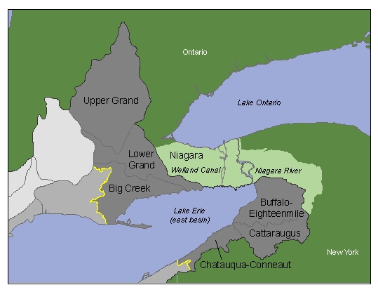
 Photo: American Fisheries Society