Bulkhead removal and activities associated with reversing hardening of shoreline. In association with Lake St. Clair nearshore and small embayment recovery
projects
Lead Agency:
OMNR / City of Windsor
Contact:
Rich Drouin; rich.drouin@ontario.ca
Partners:
EC-GLLFAS
Links:
Documents
Clinton
Project Title
Project Type
Basin
Waterbody(ies)
Status
Clinton River Watershed Assessment
Habitat monitoring and
Huron-Erie corridor
n/a
Completed
evaluation
Location:
Tributary to Lake St. Clair
Description:
Assessment of landscapes, fisheries, and aquatic habitats in the river's watershed providing a comprehensive reference for all resource management
applications.
Lead Agency:
MDNR
Contact:
J. Francis, Southfield DNR Office, 26000 W. Eight Mile Rd, Southfield, MI 48034
Lake St. Clair, Clinton, Syndenham, Lower Thames, Cedar Creek
Project Title
Project Type
Basin
Waterbody(ies)
Status
Lake St. Clair Coastal Habitat
Rehabilitation Strategies
Huron-Erie corridor
n/a
Complete
Restoration and Conservation
(workshops, tools, etc.)
Location:
Lake St. Clair
Description:
The Great Lakes Commission, in cooperation with the U.S. National Oceanic and Atmospheric Administration (NOAA) is undertaking a project to characterize
Lake St. Clair's coastal habitat and develop a restoration and conservation plan based on that characterization. The Great Lakes Commission is the principal
cooperator with NOAA and will work cooperatively with various other project partners to gather data and information about Lake St. Clair coastal habitat and
incorporate that information into a digital information resource.
Lead Agency:
Michigan Dept. Natural Resources
Contact:
Partners:
GLC, NOAA, Michigan Natural Features Inventory, MDNR
Links:
Documents
Lower Thames
Project Title
Project Type
Basin
Waterbody(ies)
Status
Thames River Habitat Assessment
Habitat monitoring and
Huron-Erie corridor
n/a
Ongoing: April 2003-2007
and Monitoring
evaluation
Location:
Thames River
Description:
This project will build on and augment several current monitoring initiatives and historical data focused on water flow, habitat availability, benthos, and
municipal drains. This project will: assess thermal and flow regime, habitat, benthos, sediment and macrophytes at traditional OMNR sites; extend Municipal
Drain data collection to matural watercourses and link all to GIS; expand benthic monitoring network.
Lead Agency:
OMNR (LEMU)/UTRCA
Contact:
B. Locke, OMNR Lake Erie Fisheries Station, R. R. #2, 320 Milo Rd., Wheatley, ON N0P 2P0
Partners:
LTVCA, LEMU, OMNR SIRD.
Links:
Documents
Detroit
River
Project Title
Project Type
Basin
Waterbody(ies)
Status
Belle Isle/ Detroit River Sturgeon
Rehabilitation Projects
Huron-Erie corridor
Detroit River
Preliminary surveys spring 2003
Habitat Restoration, Monitoring, and
(Implementation)
& 2004, Construction June
2004; Post-construction
Education Project
monitoring spring 2005 & 2006
Location:
Upper Detroit River (Belle Isle)
Description:
Three kinds of rocky substrate of representing a gradient of void space were placed on featureless, hardpan clay bottom in the upper Detroit River;
monitored for spawning by lake sturgeon and other fish; and monitored for relative predation by round goby on deposited lake sturgeon eggs.
Lead Agency:
Michigan Sea Grant; USGS is the science leader.
Contact:
Partners:
Smith Group JJR, Great Lakes Fishery Trust, Michigan DEQ, DTE Energy, City of Detroit, US Fish & Wildlife Service, US Coast Guard, Faust Marine Corp.,
Michigan DNR.
Links:
Documents
Detroit River (AOC) Restoration
Rehabilitation Strategies
Huron-Erie corridor
Detroit River
Ongoing
Priorities development
(workshops, tools, etc.)
Location:
Detroit River
Description:
Creation of "best bets" for direction rehabilitation dollars.
Lead Agency:
Detroit River Habitat Working Group
Contact:
Partners:
see #25 under "Strategies, engineering studies, Implementation"; below
Links:
Documents
Fish Community Goal and Objectives
Rehabilitation Strategies
Huron-Erie corridor
St. Clair River, Lake St. Clair, Detroit
Complete
for Lake St. Clair, the St. Clair River
(workshops, tools, etc.)
River
and Detroit River (St. Clair System)
Location:
Lake St. Clair, St. Clair and Detroit Rivers
Description:
Fish community objectives identified will provide a framework for managing fisheries resources in the St. Clair system
Lead Agency:
Lake Erie Committee, Great Lakes Fishery Commission
Contact:
R. Drouin; rich.drouin@ontario.ca
Partners:
OMNR (LEMU), MDNR, ODNR, PFBC, NYSDEC
Links:
Documents
Reference #7
Fish spawning habitat survey in the
Habitat monitoring and
Huron-Erie corridor
Detroit River
new, 2007-2008
Detroit River
evaluation
Location:
Detroit River, MI and ON
Description:
This project investigates spawning habitat use by major species in the Detroit River. Work is also underway to assess feasibility of proposed habitat
restoration for spawning reefs.
Lead Agency:
USGS GLSC
Contact:
G. Kennedy, USGS Great Lakes Science Center,1451 Green Road, Ann Arbor, Michigan 48105-2807
Partners:
USFWS, OMNR, Central MI Univ. MIDNR
Links:
Documents
Huron-Erie Corridor System Habitat
Rehabilitation Projects
Huron-Erie corridor
St. Clair River, Lake St. Clair, Detroit
2006 Pending - NFWF/U.S. EPA
Restoration Opportunities – Creating
(Implementation)
River
Sustainable Aquatic Habitat
Location:
St. Clair River, St. Clair Delta, Lake St. Clair, and Detroit River AOC's
Description:
This project will use historical and current aquatic habitat data and modeling tools developed in an ongoing GLFC/USFWS Restoration Act-supported project
to systematically identify and delineate aquatic and fish habitat restoration opportunities that protect and restore the processes responsible for creating
and maintaining the pattern and function of instream, riparian nearshore, and open-water aquatic habitats within the St. Clair River and Detroit River AOC’s
This project measures the abundance, periodicity, and habitat use of larval fishes occurring in the Detroit River.
Lead Agency:
USGS GLSC
Contact:
E. Roseman, USGS Great Lakes Science Center,1451 Green Road, Ann Arbor, Michigan 48105-2807
Partners:
USFWS, OMNR, Central MI Univ. MIDNR
Links:
Documents
St.
Clair
Plant community mapping - Lake St.
Habitat monitoring and
Huron-Erie corridor
Lake St. Clair
Ongoing: annual surveys 3-4
Clair
evaluation
weeks mid summer
Location:
Lake St. Clair
Description:
Hydroacoustic surveys of rooted plant communities within L. St.Clair. Identification and mapping of habitat based on both conventional and side-scan
sonar transects.
Lead Agency:
MDNR, USGS
Contact:
B. Haas, Lake St. Clair Fisheries Research Station, 33135 South River Road, Harrison Twp., Michigan 48045
Partners:
Oakland University
Links:
Documents
Sturgeon Habitat surveys - Lake St.
Habitat monitoring and
Huron-Erie corridor
Lake St. Clair
Ongoing: annual surveys 2-3
Clair
evaluation
weeks mid summer
Location:
Lake St. Clair and St.Clair River
Description:
Habitat analysis: Availability of habitat required for spawning and surveys for juvenile sturgeon; Identification of habitat used by juvenile (<3yr) sturgeon.
Lead Agency:
MDNR
Contact:
M. Thomas, Lake St. Clair Fisheries Research Station, 33135 South River Road, Harrison Twp., Michigan 48046
Partners:
USGS, USFWS
Links:
Documents
St. Clair River AOC - Shoreline
Rehabilitation Strategies
Huron-Erie corridor
St. Clair River
Ongoing
habitat inventory
(workshops, tools, etc.)
Location:
CAN portion of the St. Clair River
Description:
Inventory of habitat and shoreline features to be used to direct rehabilitation targets.
Lead Agency:
Contact:
R. Drouin, Lake Erie Management Unit, OMNR, 659 Exeter Road, London, ON N6E 1L3
Partners:
Links:
Documents
St. Clair, Lake St. Clair, Clinton
Project Title
Project Type
Basin
Waterbody(ies)
Status
St. Clair River - Lake St. Clair
Rehabilitation Strategies
Huron-Erie corridor
St. Clair River, Lake St. Clair
Complete
Comprehensive Management Plan
(workshops, tools, etc.)
Location:
primarily US portion of the Lake St. Clair basin
Description:
Development of a comprehensive management plan to identify causes and sources of environmental degradation, address biological and chemical
contamination, disseminate information, provide recommendations for future restoration measures
St. Clair, Upper Thames, Syndenham, Lower Thames, Lake St. Clair, Clinton, Detroit, Cedar Creek
Project Title
Project Type
Basin
Waterbody(ies)
Status
Huron-Erie Corridor Habitat
Rehabilitation Strategies
Huron-Erie corridor
St. Clair River, Lake St. Clair, Detroit
Complete
Assessment
(workshops, tools, etc.)
River
Location:
St. Clair River, St. Clair Delta, Lake St. Clair, Detroit River, Western Basin Lake Erie
Description:
This project will create a framework and design a process to systematically identify, coordinate, and implement aquatic and fish habitat restoration
opportunities in the Lake Huron to Lake Erie Corridor (Huron-Erie Corridor, HEC) within a context of water level change resulting from direct anthropogenic
hydromodification and/or long-term effects of global climate change.
Lead Agency:
The Ohio State University, University of Windsor
Contact:
S. Mackey, Habitat Solutions, Beach Park, IL 60087
Initiate a Thames River Habitat Stewardship Program to provide incentives to landowners throughout the Thames River Basin to implement riparian BMPs.
Focus will be on buffer strips, bank stabilization, livestock fencing, retiring fragile land. Related to Lake Erie via walleye stock contributions.
Lead Agency:
OMNR (Aylmer)
Contact:
Partners:
UTRCA, LEMU, Aylmer District, LTVCA; other potential partners include Perth, Middlesex, Oxford, & Elgin counties.
Links:
Documents
Thames River Watershed Barriers
Rehabilitation Projects
Huron-Erie corridor
n/a
Ongoing
Assessment
(Implementation)
Location:
Thames River
Description:
Over 180 barriers have been identified in the Thames River basin. These impact water quality and fish movement & migration (incl walleye which utilize lake
Erie). This project will assess impacts and prioritize barriers for removal. 20 key impoundments will be assessed and prioritized for mitigation or removal and
a detailed plan outlining action in 2004 will be developed for 3 priority impoundments.
Lead Agency:
OMNR (LEMU)/UTRCA
Contact:
B. Locke, OMNR Lake Erie Fisheries Station, R. R. #2, 320 Milo Rd., Wheatley, ON N0P 2P0


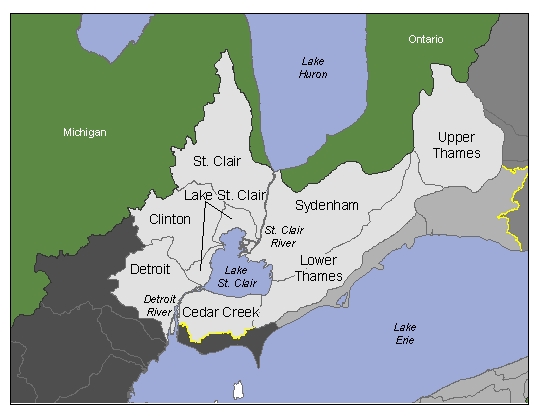
 Photo: American Fisheries Society